Planning application
RES has submitted a Section 36 application to the Scottish Government’s Energy Consents Unit (ECU) for its 14-turbine Blair Hill Wind Farm proposal, located 2.7km north of Newton Stewart in Dumfries and Galloway.
Electronic copies of the planning application and accompanying documents can be viewed or downloaded by clicking on the links below.
- Application letter
- Public Notice (published in the Galloway News, Edinburgh Gazette and The Scotsman newspapers)
- Design and Access Statement
- Planning Statement
- Pre-application Consultation Report
- Socio-Economic Report
Volume 1 Environmental impact Assessment Report - Main Report
Volume 2a Environmental impact Assessment Report - Figures except LVIA
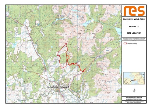
- Figure_1.1 Site Location
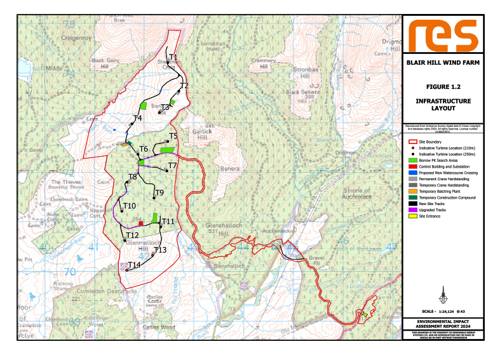
- Figure_1.2 Infrastructure Layout
- Figure_2.1a Turbine Elevation 250m Tip Height
- Figure_2.1b Turbine Elevation 210m Tip Height
- Figure_2.2a Typical Wind Turbine Gravity Foundation
- Figure_2.2b Typical Wind Turbine Piled Foundation
- Figure_2.3 Typical Crane Hardstand
- Figure_2.4 Typical Access Track
- Figure_2.5 Indicative Site Entrance layout
- Figure_2.6 Indicative Old Edinburgh Road Junction
- Figure_2.7 Typical Track Cross Drainage
- Figure_2.8 Typical Water Crossing
- Figure_2.9 Indicative Penkiln Burn Crossing
- Figure_2.10 Typical Batching Plant Layout
- Figure_2.11 Substation layout
- Figure_2.12 Substation elevation
- Figure_2.13 Typical Communications Mast
- Figure_2.14 Typical Cable Trench Details
- Figure_2.15 Typical Temp Construction Compound
- Figure_2.16 Indicative Borrow Pit
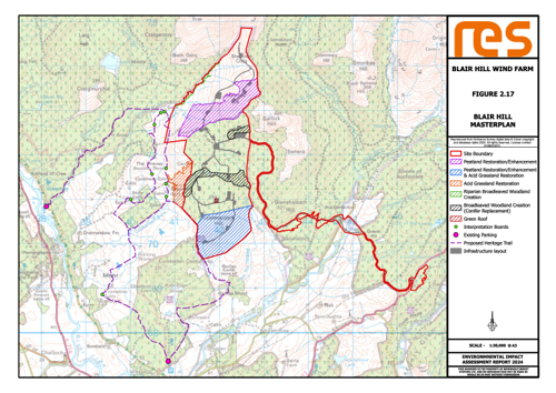
- Figure_2.17 MasterPlan
- Figure_3.1 Environmental Designations
- Figure_3.2 Design Iteration A - D
- Figure_3.3 Design Iteration E - H
- Figure_3.4 Design Iteration I - J
- Figure_7.1.1 Historic Environment Records Assets 1 - 3
- Figure_7.1.1 Historic Environment Records Assets 4 - 6
- Figure_7.2 Designated Cultural Heritage (CH) Assets
- Figure_7.3 CH Viewpoints
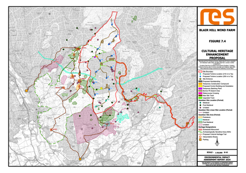
- Figure_7.4 CH Enhancement Proposal
- Figure_8.1 Designated Sites
- Figure_8.2 Carbon Peatland
- Figure_8.3 National Vegetation Classification (NVC) Overview
- Figure_8.3 NVC Tiles page 1
- Figure_8.3 NVC Tiles page 2
- Figure_8.3 NVC Tiles page 3
- Figure_8.3 NVC Tiles page 4
- Figure_8.4 Groundwater Dependent Terrestrial Ecosystems (GWDTE) Overview
- Figure 8.4 GWDTE Tiles
- Figure_8.5 Peatland Condition Classification (PCA) Overview
- Figure_8.5 PCA Tiles
- Figure_8.6 PCA WoodScrub
- Figure_8.7 PCA Grazing
- Figure_8.8 PCA Sphag Overview
- Figure_8.8 PCA Sphag Tiles
- Figure_8.9 Protected Species (PS) Overview
- Figure_8.9 PS Tiles
- Figure_8.10 Anabat Locations
- Figure_8.11 Common Pipistrelle
- Figure_8.12 Soprano Pipistrelle
- Figure_8.13 Nyctalus
- Figure_8.14 Salmon
- Figure_8.15 Trout
- Figure_8.16 OBEMP
- Figure_9.1 Study Areas
- Figure_9.2 Designated Sites
- Figure_9.3 Vantage Points & View Sheds (VPVS) Y1
- Figure_9.4 VPVS Y2
- Figure_9.5 Scarce Breeding Birds Study Area
- Figure_9.6 Black Grouse
- Figure_9.7 Breeding Wader
- Figure_9.8 Black Grouse Lek Activity
- Figure_9.9 Black Grouse Flight Activity
- Figure_9.10 Raptor Activity
- Figure_9.11 Goshawk & Peregrine Falcon Flight Activity
- Figure_9.12 Hen Harrier Flight Activity
- Figure_9.13 Merlin Flight Activity
- Figure_9.14 Red Kite Flight Activity
- Figure_9.15 Curlew, Golden Plover & Lapwing Flight Activity
- Figure_9.16 Greylag Goose, Pink-Footed Goose & Herring Gull Flight Activity
- Figure_9.17 Goose Activity
- Figure_10.1 Site Study Area
- Figure_10.2 Hydrological Features
- Figure_10.3 Superficial Geology
- Figure_10.4 Peat Classification
- Figure_10.5 Peat Depth
- Figure_10.6 Bedrock Geology
- Figure_10.7 Hydrogeological Features
- Figure_10.8 Watercourse Crossings
- Figure_10.9 Private Water Supply Risk Assessment
- Figure_10.10 Ground Water Dependent Terrestrial Ecosystems
- Figure_11.1 Study Area
- Figure_11.2 Traffic Count Locations
- Figure_12.1 Predicted Sound Footprint
- Figure_14.1 Site Boundary Forest Study Area
- Figure_14.2 Baseline Forest Cover 2029
- Figure_14.3 Baseline Forest Within Boundary 2029
- Figure_14.4 Areas of Ancient and Native Woodland
- Figure_14.5 Infrastructure Felling Within Drannandow Forest
- Figure_14.6 Infrastructure Felling Within Lamachan Forest
- Figure_14.7 Infrastructure Felling in Queensway
- Figure_14.8 Ancient Native Wood in Felling Area
- Figure_14.9 Management Felling Lamachan Queensway
- Figure_14.10 Felling Restock Lamachan Queensway
- Figure_15.1 Aviation Lighting Scheme
- Figure_16.1 Shadow Flicker Assessment
Volume 2b Environmental impact Assessment Report - LVIA Figures
- Figure_6.1 Site Context
- Figure_6.2 Landscape Policy Context
- Figure_6.3 Landscape Character
- Figure_6.4 Topography
- Figure_6.5 ZTV Bare Ground
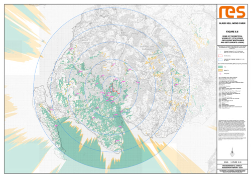
- Figure_6.6 ZTV Woodland and Settlements
- Figure_6.7 Character ZTV W&S Combined
- Figure_6.8 Cumulatives
- Figure_6.9 ZTV Cumulatives Operational & Construction
- Figure_6.10 ZTV Cumulatives Planning
- Figure_6.11 ZTV Cumulatives Selected Planning
- Figure_6.12 Existing Light Pollution
- Figure_6.13 Night ZTV
- Figure_6.14 Night ZTV Turbine Lighting Intensity
Volume 2c Environmental impact Assessment Report - Photomontages
- Figure_6.15 Viewpoint 1 - Drumwhirn Cairn, Moor of Barclye
- Figure_6.16 Viewpoint 2 - Corsbie Road, Newton Stewart
- Figure_6.17 Viewpoint 3 - NCR73 / A714 south of Newton Stewart
- Figure_6.18 Viewpoint 4 - Glenvernoch Fell / Hill of Ochiltree
- Figure_6.19 Viewpoint 5 - NCR7 on Minor Road North of Glentrool Village (Updated May 2025)
- Figure_6.20 Viewpoint 6 - Cairnsmore of Fleet
- Figure_6.21 Viewpoint 7 - Merrick
- Figure_6.22 Viewpoint 8 - A75 near Creetown
- Figure_6.23 Viewpoint 9 - Kirkcowan
- Figure_6.24 Viewpoint 10 - NCR73 on Minor Road North of Wigtown
- Figure_6.25 Viewpoint 11 - Benniguinea Lookout (Updated May 2025)
- Figure_6.26 Viewpoint 12 - Mochrum Lochs RSA, Moor of Drumwall
- Figure_6.27 Viewpoint 13 - Minor Road near Barhill Station
- Figure_6.28 Viewpoint 14 - Southern Upland Way near Artfield Fell
- Figure_6.29 Viewpoint 15 - A746 North of Whithorn
- Figure_6.30 Viewpoint 16 - Byne Hill
- Figure_6.31 Viewpoint 17 - A712 east of Corsock
- Figure_6.32 Viewpoint 18 - Southern Upland Way near Stranraer
- Figure_6.33 Viewpoint 19 - Sandhead
- Figure_6.34 Viewpoint 20 - Monigaff Parish Church
- Figure_6.35 Viewpoint 21 - Lamachan Hill
- Figure 6.35a Viewpoint 21a - Lamachan Hill (Added May 2025)
- Figure_6.36 Viewpoint 22 - Millfore
- Figure 6.36a Viewpoint 22a - Millfore (Added May 2025)
- Figure_6.37 Viewpoint 23 - Meikle Millyea
- Figure 6.37a Viewpoint 23a - Meikle Millyea (Added May 2025)
- Figure_6.38 Viewpoint 24 - Innerwell Fishery approach
- Figure_6.39 Viewpoint 25 - Penninghame Estate pond, Castle Stewart
- Figure_6.40 Viewpoint 26 - Challoch Church
- Figure_7.5 VPCH1 Dalvaird Cairn
- Figure_7.6_VPCH2 The Thieves Standing Stones
- Figure_7.7_VPCH3_Drumfern Cairn
- Figure_7.8_VPCH4_Nappers Cottage
- Figure_7.9_VPCH5_Cordorcan Cairn
- Figure_7.10_VPCH6_Drumwhirn Cairn
- Figure_7.11_VPCH7_White Cairn
- Figure_7.12_VPCH8_Cairnsmore of Fleet Cairn
- Figure_7.13_VPCH9_Garlies Castle
- Figure_7.14_VPCH10_Deils Dike
- Figure_7.15_VPCH11_Cumloden House
- Figure_7.16_VPCH12_Drannandow Farmhouse
Volume 3 Environmental impact Assessment Report - Technical Appendices
- TA4.1 ECU Scoping Opinion 13.11.2023
- TA4.2 ECU Scoping Opinion Addendum 06.02.2024
- TA6.1 LVIA Glossary and Methodology
- TA6.2 LVIA Viewpoint Selection
- TA6.3 LVIA Viewpoint Descriptions
- TA6.4 Wild Land Area Assessment
- TA6.4 Wild Land 001 Map Relative Wildness
- TA6.4 Wild Land 002 WLA ZTV
- TA6.5 Residential Properties
- TA6.5 Residential Properties ZTV Hub
- TA6.5 Residential Properties ZTV Tip
- TA6.5 VP Glenshalloch
- TA6.5 P16 Glenshalloch
- TA6.5 P16 Glenshalloch aerial
- TA6.5 Residential Visual Amenity Assessment
- TA6.6 Aviation Lighting Intensity Report
- TA7.1 Cultural Heritage Gazetteer
- TA7.2 Heritage Appraisal
- TA7.3 Cultural Heritage Enhancement Proposal
- TA7.4 Cultural Heritage Consultation
- TA8.1 NVC & Habitats Survey Report
- TA8.2 Protected Species Survey Report
- TA8.3 Bat Survey Report
- TA8.4 Fish Survey Report
- TA8.5 Species Protection Plan
- TA8.6 Outline Biodiversity Enhancement Plan (OBEMP)
- TA9.1 Annex A
- TA9.1 Annex B
- TA9.1 Annex C
- TA9.1 Annex D
- TA9.1 Annex E
- TA9.1 Ornithology Technical Appendix
- TA10.1 Watercourse Crossing Schedule
- TA10.1 WCS Dwg1
- TA10.2 Private Water Supply Risk Assessment (PWSRA)
- TA10.2 Private Water Supply Annex 2 Form
- TA10.2 PWSRA Dwg1 Consul
- TA10.2PWSRA Dwg2 HydFt
- TA10.2 PWSRA Dwg3 Superficial
- TA10.2 PWSRA Dwg4 Bedrock
- TA10.2 PWSRA Dwg5 Assess
- TA10.3 GWDTE Risk Assessment
- TA10.3 GWDTE Annex 2 Drawing 1
- TA10.4 Peat Management Plan (PMP)
- TA10.4 PMP Annex2
- TA10.4 PMP Dwg1 Location
- TA10.4 PMP Dwg2 Layout
- TA10.4 PMP Dwg3a Peat Depth
- TA10.4 PMP Dwg3b Peat Depth
- TA10.5 Peat Landslide Hazard Risk Assessment (PLHRA)
- TA10.5 Peat Landslide Risk Annex2
- TA10.5 Peat Landslide Risk Annex3
- TA10.5 PLHRA Dwg1 Location
- TA10.5 PLHRA Dwg2 Layout
- TA10.5 PLHRA Dwg3 Superficial
- TA10.5 PLHRA Dwg4 Bedrock
- TA10.5 PLHRA Dwg5a Peat Depth
- TA10.5 PLHRA Dwg5b Peat Depth
- TA10.5 PLHRA Dwg6 Slope
- TA10.5 PLHRA Dwg7 Likelihood
- TA10.5 PLHRA Dwg8 Geomorph
- TA10.6 Outline Borrow Pit Management Plan
- TA11.1 Abnormal Loads Route Assessment 1
- TA11.1 Abnormal Loads Route Assessment 2
- TA11.1 Abnormal Loads Route Assessment 3
- TA12.1 Issues Scoped Out of Acoustic Assessment
- TA12.2 Calculating Standardised Wind Speeds
- TA12.3 Background Sound Survey Photos
- TA12.4 Acoustic Instrumentation Records
- TA12.5 Acoustic Charts
- TA12.6 Suggested Acoustic Planning Conditions
- TA15.1 Lighting CAA Letter RES_20241213
- TA17.1 Outline Environmental Management Plan
- TA17.2 Outline Pollution Prevention Plan
Volume 4 Environmental impact Assessment Report - Non-Technical Summary
.
Site Location
Infrastructure Layout
Click on image to enlarge
Masterplan
Click on image to enlarge
Cultural Heritage Enhancement Proposal
Click on image to enlarge
Outline Biodiversity Enhancement Plan
Click on image to enlarge
ZTV incl. Woodland and Settlements
Click on image to enlarge
The planning application may also be viewed on the Energy Consents Unit’s (ECU) website by searching for application ECU00004878 at https://www.energyconsents.scot/ApplicationSearch.aspx.
Hard copies of the documentation are available at the following locations during normal opening hours for public viewing:
- Newton Stewart Library, Church Street, Newton Stewart,
DG8 6ER - John McNeillie Library, Wigtown County Buildings, Wigtown, DG8 9JH
A statutory consultation period is being held by the ECU to enable the public, as well as key consultees, to submit formal representations on the proposals.
Feedback will be assessed against the proposals and a determination made by Scottish Ministers.
You can submit a representation to the ECU in the following ways:
- Online: Accessing the Online Planning Information System, and leave a comment on application ECU00004878 at https://www.energyconsents.scot/ApplicationDetails.aspx?cr=ECU00004878
- Email: Contact the Energy Consents Unit at representations@gov.scot, quoting the reference ECU00004878 including your full name, address, and the date in your email
- Post: Writing to Energy Consents Unit, Scottish Government, 5 Atlantic Quay, 150 Broomielaw, Glasgow G2 8LU and quoting the reference: ECU00004878, your full name, address, and the date.
All representations should be made no later than 2nd May 2025 although Scottish Ministers may consider representations after this date.

